Past Frog Lane the canal passed through a small copse before emerging onto this field, which of course was bisected by the canal when it existed. The upper section of field that has been turned over actually marks where the canal was as it ran along the boundary between the two different sections of the field, across the centre of the photograph, the canal passing from left to right to Basingstoke.
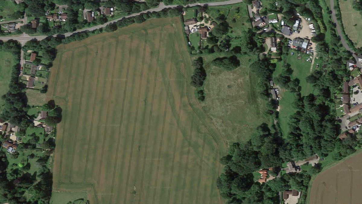
As can be seen from Google Aerial the course of the Basingstoke canal is still quite evident across the fields at Mapledurwell. At bottom right is the Coach and Horses/East Side at Frog Lane. Along the top is Greywell Road (now the course of the canal) and at far left is the crossroads where Luke’s bridge across the canal once stood.
Map source: Google Aerials.

Course of the canal (marked in red) across fields parallel to Frog Lane. The houses are part of Mapledurwell. Greywell Road is out of sight beyond the clump of trees on the far right, but is seen in the next pictures.

A continuation of the route from the previous picture, this time looking from the Greywell Road. The red line indicates the canal’s approximate route as it crossed the field from Frog Lane (sited within trees in distance) to Greywell Road whose boundary is marked by this fence.
")
The new Greywell Road is on the route of the canal – the parked cars are on the old Greywell Road.
Greywell Road was widened to this point, and then diverted onto the former Basingstoke canal as that came across the fields from Frog Lane. Previously both canal and the old road ran parallel for a short distance towards Lukes Bridge.

Greywell Road/Basingstoke Canal route at Lukes Bridg.
This view looks along the Basingstoke Canal! I know its not there now however the car seen in the above picture is at the point where Lukes Bridge once stood. There is nothing left of the canal on this section, save for the hedges on the left hand side further up which are part of the canal’s southern boundary.

Mapledurwell was often billed as a location on the Basingstoke Canal. Here is a modern day view of the entrance to the village – without the canal of course! More than a hundred years ago this would have been a towpath walker’s view looking along the Basingstoke Canal towards Lukes bridge. This 2009 view shows a sign saying thieves beware – ever wonder who were the people responsible for stealing the canal?

Looking in the other direction along Greywell Road, where it climbs to cross the M3. It leaves the southern boundary of the Basingstoke Canal quite visible as both routes now take different alignments. The red lines mark approximately the canal. The modern fencing and electric cable masts clearly mark the former canal’s southern boundary.

Recent work installing this new fence has at least cleared the area immediately before the M3. This is a view looking along the Basingstoke Canal alignment towards Hatch. The nearer, new, fence is about in the middle of the canal alignment whilst the farther fence marks the west boundary of the canal. Greywell Road is up on its embankment to the right rising to cross the M3. In this and the previous view the same electricity pole can be seen.
Greywell Road, at its crossing over the M3 (shown below) parallels the canal’s route, as the former route also turned to the M3. The lorry on the right indicates the canal’s route as it came out of the trees, and the van on the left (car overtaking it) is on the canal’s alignment where it then began to curve towards the photographer. The centre of the eastbound carriageway is approximately where the canal’s southern boundary lay as it progressed towards the footbridge.

View looking east to Greywell Road bridge.
 on the alignment of the Basingstoke Canal")
These units have recently been built (2008) on the alignment of the Basingstoke Canal. Evidently the former canal alignment was obliterated to permit these units to be built. One does wonder if the council has any remaining serious aspirations about extending the canal back into Basingstoke? I do not think so.
Compare those above pictures with the older views below…

Another view of the M3, again from Greywell Road Bridge – the Basingstoke Canal ran along the right side of the motorway – the flat land where the two fences lie being part of the former canal route, although the M3 took up a larger part of the canal’s alignment.
The footbridge in the distance gives a good view of the canal’s alignment as it passed along here and back across the M3 towards the trees on the far left, before making a great sweep round to the right and back across the M3, passing behind the buildings seen amongst the trees near the top right of the picture. The red lines show roughly where the towpath was, the canal itself being to the left and so its centre is more or less akin to the motorway’s boundary as marked by the fence alongside it. The red line across the motorway show the canal’s alignment as it headed south into the trees before looping back northwards to enter Old Basing.

The north end of the footbridge stands on the canal’s alignment, as seen here in this view. The photographer is standing on what was the northern side of the canal’s boundary, and the slight, but detectable footpath, as it curves gently to the left towards the larger tree in the middle of the photograph, indicates the former canal’s route, whilst the red line marks the former towpath.
Next: Old Basing Village.
GREYWELL TO BASINGSTOKE PAGES:
Introduction / Greywell Hill / Tunnel – Brick Kiln Bridge / Penny Bridge – Frog Lane / Mapledurwell – Hatch / Old Basing Village / Basing House – Swing Bridge / Ringway – Basingstoke